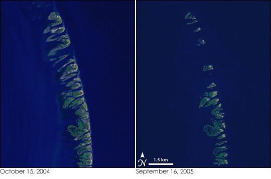
Chandeleur Islands
The Chandeleur Islands are a chain of barrier islands located in the Gulf of Mexico. These islands are about 50 miles long and mark the outer boundary of the Chandeleur Sound. The Chandeleur Islands are the easternmost part of Louisiana and make up the Breton National Wildlife Refuge.
The Chandeleur Islands were formed more than 2,000 years ago. Pierre Le Moyne d'Iberville later founded the islands while searching for the mouth of the Mississippi River along the Gulf Coast. The islands got their name on February 1, 1700, when Pierre christened them on the eve of Fête de la Chandeleur, a Christian feast day.
Prior to a hurricane in 1915, farms and a fishing village were located on the islands. A lighthouse, known as Chandeleur Island Light, was built on one of the islands in 1895 and it stood as a landmark for mariners and pilots traveling over the Gulf of Mexico.
The islands are constantly being eroded by waves and storm surges, but since the late 1800s, the islands have also been gradually shrinking and migrating towards land. During the 1980s a survey team found that the islands would only be in existence for about 300 more years. The Chandeleur Islands lost about 20-30 feet of land each year prior to 1996. Between 1996 and 2004, the islands started losing around 300 feet of land per year. Hurricane Georges destroyed the Chandeleur Islands in 1998, leaving the Chandeleur Island Light in the middle of the Gulf.
The barrier islands started to recover but were stuck once again, this time by Hurricane Katrina in 2005. The effects of the hurricanes destroyed the lighthouse and reduced the islands to sub-surface formations. A study was done by geologists from the University of New Orleans in 2006 which found that the usual sediment patterns that rebuilt the islands after major storms haven’t been restored since Hurricane Katrina tore through the area. Marine geologists have also found evidence of landslides on the seafloor that are sliding toward the Gulf of Mexico, possibly allowing stronger waves to reach the islands and causing more erosional impact. The islands could be completely underwater in just decades due to isolation from the Mississippi River Delta sediment, damaging storms, and rising sea level.
The Chandeleur Sound lies between the Louisiana mainland and Chandeleur Islands in St. Bernard Parish. This sound is located north of the Breton Sound and south of the Mississippi Sound and was formed by the waters of the Mississippi River and the Gulf of Mexico mixing together.
The average water temperature of the Sound ranges between 70˚ to 84˚F. The humidity is often high, ranging from 73% and 84%, and causes lots of clouds to form overhead. With all the clouds, the area sometimes receives as little as 4 hours of daily sunlight.
Chandeleur Sound has served as an excellent spot for fishing. With an abundance of fish, including Redfish and Speckled trout, thriving in the region, it’s allowed for humans to settle as early as 1718, when the French arrived in New Orleans.
Image From Jesse Allen, NASA Earth Observatory, using data provided courtesy of Laura Rocchio, NASA Landsat Project Science Office., Public domain, via Wikimedia Commons


